The National Underground Asset Register (NUAR)
Thoughts on how to maximise the value of NUAR data.
Working as a Senior Policy Advisor on the National Underground Asset Register (NUAR) is one of the most interesting things that I’ve done in my career so far.
I think it is a great example of central government successfully intervening in our national data ecosystem to deliver value to wider society, which is probably why some of the NUAR team are now leading work on the National Data Library - something I think will definitely help bring clarity, and direction, to the cause.
If you’re not familiar with NUAR, have a read of this and this - both articles provide good overviews of the project and its benefits.
However, here’s a brief summary to get you up to speed any way:
-
Utility companies and local authorities all record the location of their underground assets using different systems and data standards.
-
They provide this data to those who have a right to access it in different formats and ways that aren’t always consistent.
-
The NUAR project was created to solve the issues that resulted from the above.
-
NUAR developed a data model to standardise the way that underground asset data is recorded in England, Wales, and Northern Ireland.
-
NUAR’s data model is actually an implemention of the OGC Model for Underground Data Definition and Integration - but that’s another story.
-
Scotland do things differently. The Community Apparatus Data Vault system (VAULT for short) is a layer of information included in the Scottish Road Works Register (SRWR) and serves a similar purpose to NUAR.
-
Although the data models are different, alignment between VAULT and NUAR is definitely something that should be explored in the future.
Anyway, back to NUAR…
-
To showcase the benefits of standardising underground asset data, the NUAR project initially focused what is now known as the “safe dig use case”.
-
This use case aims to improve how underground asset data is accessed when utility companies, and local authorities, are planning and carrying out street works/excavations - primarily to save time collating data from multiple sources and prevent accidental asset strikes. NUAR’s impact assesssment for primary legislation is built around this use case.
-
In order to implement this use case, the NUAR project worked with the utility sector, and local authorities, to map their existing underground asset data to the NUAR data model.
-
The project then created a centralised source of all this information and developed a user interface to access it for the purposes of safe digging.
Voilà, you now have the National Underground Asset Register (NUAR), which will be managed by Ordnance Survey going forward.
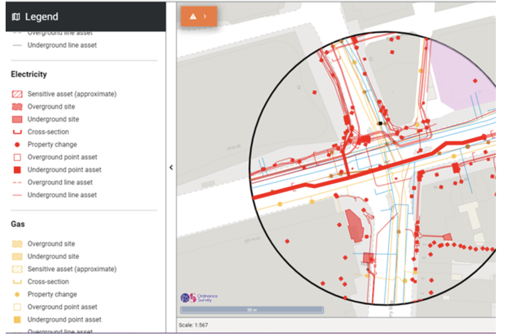 Example of the NUAR user interface.
Source: AtkinsRéalis
Example of the NUAR user interface.
Source: AtkinsRéalis
That was a very high level overview of NUAR, but hopefully it gives you a basic idea of what it’s all about.
If you want to know more about NUAR the links in the summary above will be a good place to start - watch this video from Northumbrian Water to see the safe dig use case in action as well.
Now, let’s get onto the main aim of this blog post.
Beyond the safe dig use case
Essentially, the NUAR project has guaranteed us 3 fundamental things:
-
A standardised data model for underground assets, the NUAR data model, which has been adopted by the utility sector and local authorities across England, Wales, and Northern Ireland.
-
Legislation to legally mandate the provision of underground asset data from Asset Owners (mainly utility companies and local authorities) to central government meeting the standards set out in the NUAR data model - check out the data use and access bill for more details.
-
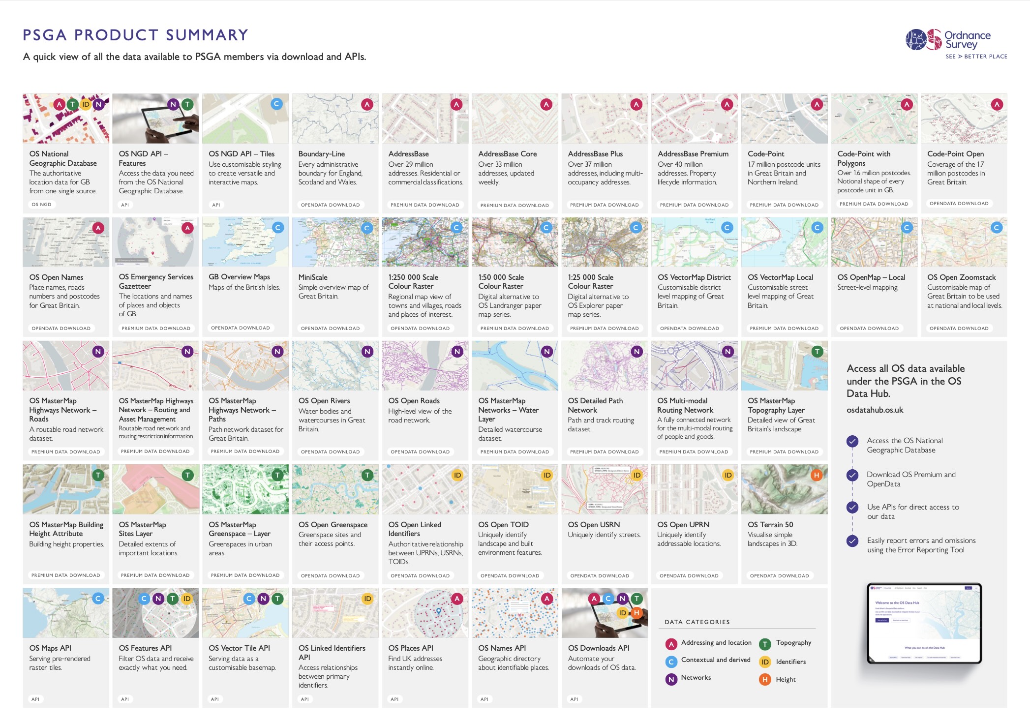
A centralised source of this underground asset data managed by Ordnance Survey - they are also responsible for managing other high value geospatial data assets in Great Britain such as the National Geographic Database (NGD).
NUAR’s true potential stems from leveraging these 3 things.
However, how do we do this?
Here’s what I think:
-
I believe that NUAR’s data model was fundamentally designed to enable us think about/analyse underground asset networks holistically, not just prevent excavation accidents through revealing where underground assets are located.
-
The initial safe digging use case was an entry point for the data model to be applied in a real-world scenario - for those who work in the utility sector, this initial use case is essentially a PAS 128 type D survey on steroids.
-
This approach was brilliant as it provided a clear, immediate value proposition for the data with a user interface focused on one element of the street works process.
-
However, the true potential of NUAR extends far beyond this initial application - this is also noted in its impact assesssment.
-
My hope is that we’ll gradually shift away from focusing solely on the user interface and the initial use case (something I know is already happening). Perhaps in the future, the private sector will handle the safe dig use case, while Ordnance Survey focuses on what it does best: managing data.
-
You could argue that the NUAR project initially focused on answering a simple question: “Where are underground assets located?”
-
However, I think we’ll naturally move towards more sophisticated questions such as:
-
“Where are underground assets located in relation to each other?” (asset density use cases are already being explored with h3 hex grids).
-
“How healthy are our underground assets?” (life expectancy, condition, etc.).
-
“What underground assets should be replaced?”
-
“How can we install new underground assets in the most efficient and least disruptive way possible?”
-
“Where are underground assets located in relation to other points of intertest such as traffic sensitive roads or streets with special engineering difficulties?” (it’s important to shift focus away from the assets themselves and towards other parts of the street and road network).
-
Feel free to ping me with any other questions you can think of as well.
-
-
Most data use cases can be boiled down to answering base level questions like the ones above.
-
Although useful as a starting point, we should spend less time answering specific where/why/what/how questions for specific groups of people (e.g. the safe dig use case).
-
What we should avoid is Ordnance Survery managing NUAR data and also numerous, bespoke one-off maps.
-
One-off maps for specific use cases, such as the British Geological Survey’s (BGS) mining hazard 1km hex grid map available as OS open data, or the British Geological Survey’s (BGS) GeoSure 5km hex grid map also available as OS open data, can be extremely valuable.
-
That being said, I think we should avoid focusing our efforts on this when thinking about NUAR data.
-
The real opportunity for NUAR lies in integrating it within the very fabric of our geospatial data infrastructure in order to:
-
Think about our underground asset networks holistically as a system among other systems that exist in and around the street and road networks (green spaces, waterways, pedestrian routes, buildings, etc.).
-
Enable the public sector to answer questions related to the above independently in a safe and secure manner.
-
-
To do this we should think about NUAR in relation to 2 things: Ordnance Survey’s National Geographic Database (NGD) and Unique Street Reference Numbers (USRNs).
The next section covers this in a little more detail.
I can already hear the “but what about security and privacy concerns?” brigade in the distance - and you’d be right to raise these concerns.
Fear not, I’m not going to suggest that we just dump all NUAR data into the NGD without any thought.
I will address these concerns in the next section and use the National Protective Security Authority (NPSA) paper on securing underground asset data as a guide.
Security-minded integration of NUAR with our national data ecosystem
As I’ve stated, the National Underground Asset Register (NUAR) represents a valuable national data asset initially created for a safe digging use case, but its potential extends far beyond this.
Integrating NUAR with the OS National Geographic Database (NGD) could create a more comprehensive national data resource, while maintaining appropriate security protections.
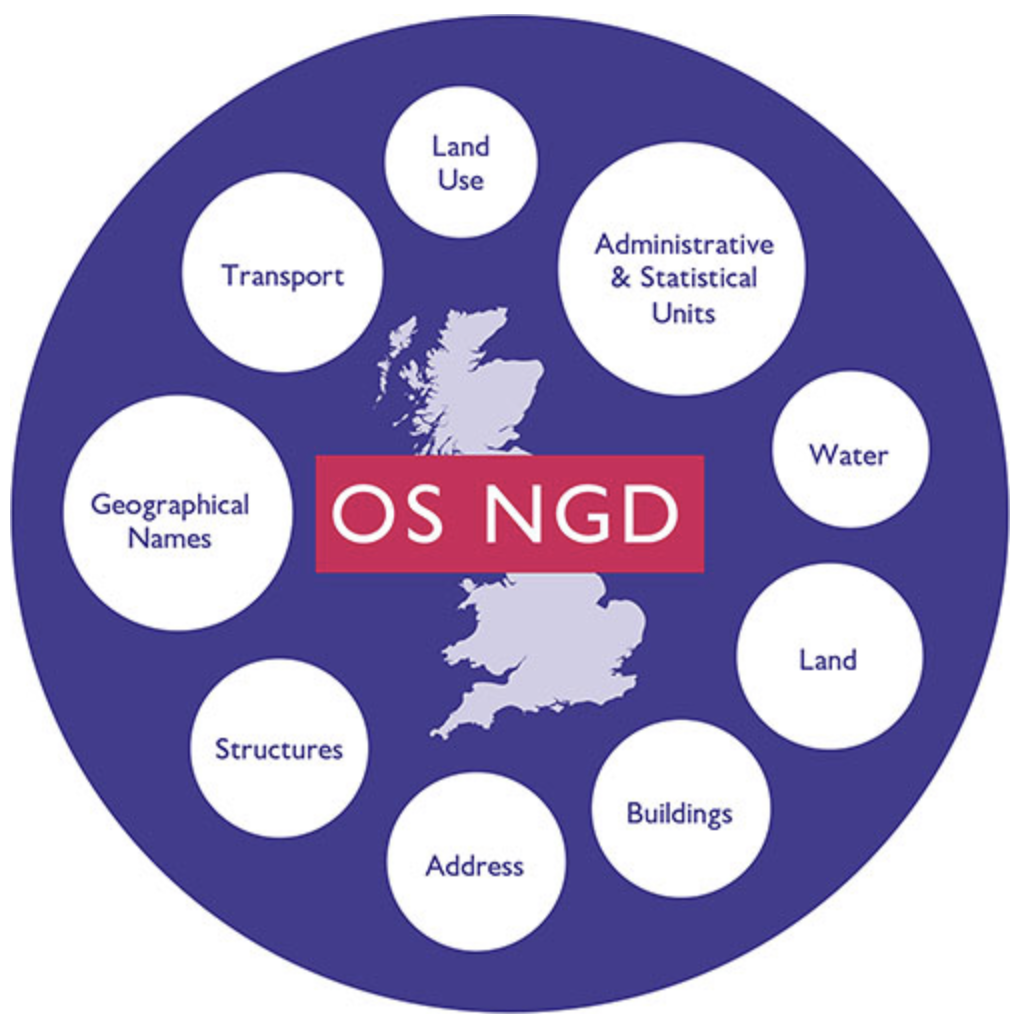 Data themes available within the OS National Geographic Database (NGD).
Source: Ordnance Survey
Data themes available within the OS National Geographic Database (NGD).
Source: Ordnance Survey
The NPSA paper on “Securing Underground Asset Data” provides important guidance that we should follow, particularly these key principles:
-
Different access levels for different use cases: While safe digging requires granular asset location data (x,y,z coordinates), many other use cases don’t need this level of detail.
-
Aggregation rather than pinpoint accuracy: For many applications, aggregated data (such as using hexagon grid representation at various resolutions) provides sufficient utility while protecting sensitive infrastructure.
-
Authentication of legitimate access: Ensuring only authorised parties can access data at appropriate levels of detail.
Street-Level Integration: The USRN Advantage
One of NUAR’s most valuable, yet overlooked, features is the incorporation of Unique Street Reference Numbers (USRNs) in its data model (local reference attributes).
Here’s why I think this could be used to unlock NUAR’s full potential:
- USRNs have their own coordinates.
- USRNs are linked identifiers to other relevant national datasets.
This allows for:
- Street-level aggregation of utility information without exposing exact underground asset coordinates.
- Joining NUAR data with other data in the NGD.
- Joining NUAR data with other national datasets, which also reference USRNs - there are a few!
 USRNs are the ultimate linked identifier.
Source: GeoPlace
USRNs are the ultimate linked identifier.
Source: GeoPlace
Organisations such as GeoPlace have adopted this approach for national datasets such as the National Street Gazetteer (NSG).
You can access attributes from the National Street Gazetteer through the Routing and Asset Management Information (RAMI) features in the National Geographic Database (NGD) - USRNs play a key role here.
Through open source projects, such as the Rapid Street Assessment Tool, I have built prototypes on top of this.
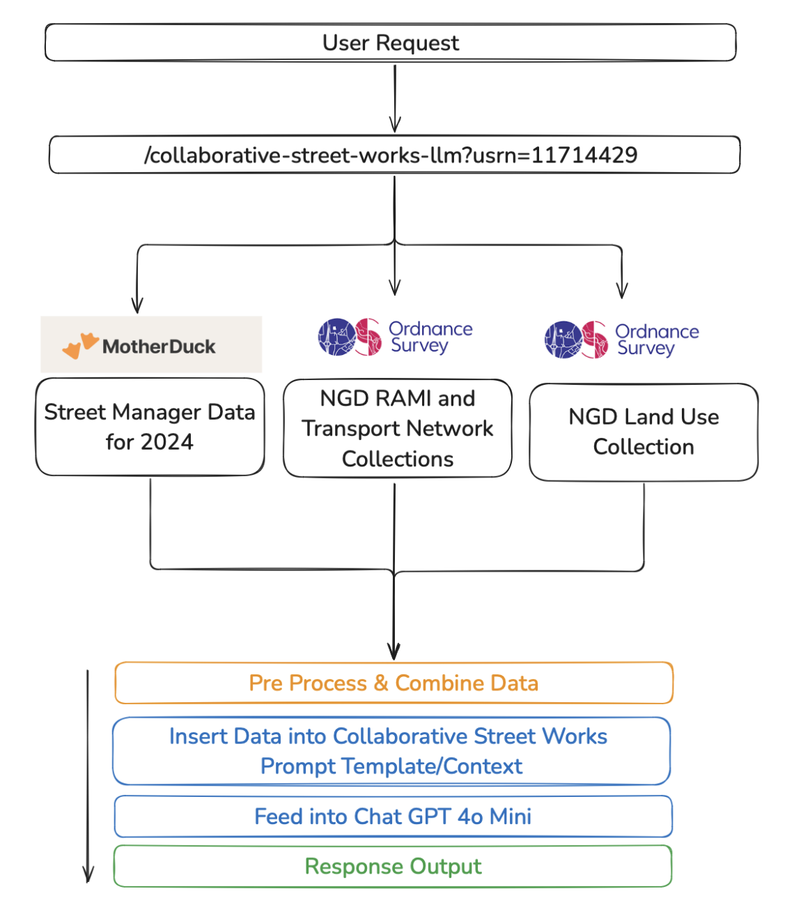 Rapid Street Assessment Flow.
Source: Chris Carlon
Rapid Street Assessment Flow.
Source: Chris Carlon
The Rapid Street Assessment Tool uses USRNs to join data from the NGD with other national datasets, such as Street Manager, to rapidly assess the street and road network when planning street works.
I have also built prototypes for other street work use cases, such as word on the street, that uses Street Manager data, USRNs, UPRNs, and other datasets to look at the impact of street works on our roads.
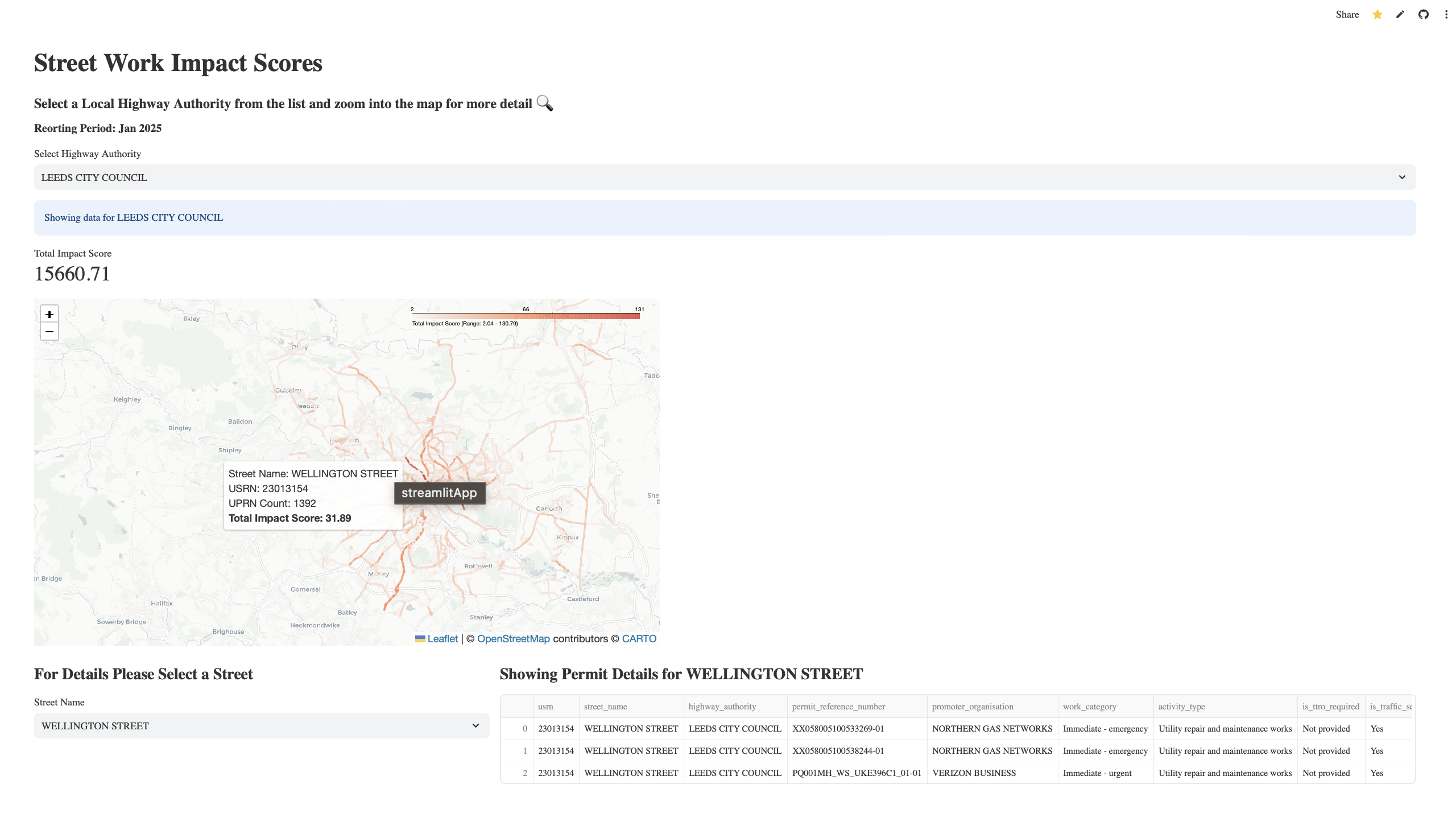 Example map from Word on the Street.
Source: Chris Carlon
Example map from Word on the Street.
Source: Chris Carlon
My prototypes are far from perfect, but they do show how we can use USRNs to join data from the NGD with other national datasets to drive a data-minded approach when thinking about the street and road network.
With all this in mind, what am I actually suggesting for NUAR?
Proposed Approach for NGD Integration
I propose a street-level (USRN) integration approach that would carefully expose selected NUAR attributes and set limits on how much data you can query at once, in a given time frame, and in a given area.
Access would be limited to certain public sector organisations and only available through the existing Public Sector Geospatial Agreement (PSGA) framework.
We don’t need to give people access to everything, but we should focus on exposing certain attributes in a way that enables the public sector to work in a secure, independent, and efficient manner to develop their own use cass.
For example, we could expose the following attributes at a USRN level via a new “Underground Asset Summary” feature in the NGD:
Utility Network Attributes
- Utility Types: Electric, Gas, Water, Sewer, Telecommunications, Drainage, Fuel and Chemicals, Thermal, Transport Signalling
- Utility Subtypes: More specific classifications like Potable Water, Surface Water Sewer, Foul Sewer, Telecommunication, Electric Power, etc.
Physical Characteristics Attributes
- Materials: PVC, HDPE, Cast Iron, Concrete, Steel, Copper, etc.
- Installation Methods: Trenching, Directional Drilling, Open Cut, Ducted, Moling, etc.
- Conveyance Categories: Distribution, Transmission, Collection, Service, etc.
- Conveyance Methods: High/Medium/Low Pressure, High/Medium/Low Voltage, Gravity, etc.
Spatial Attributes
- Underground Status: Underground, Aboveground, Overhead, Surface, Submerged, Mixed
- Location Types: Carriageway, Footpath, Verge, Field, etc.
The new Underground Asset Summary feature could be integrated into already exsiting themes and collections - potentially the Transport theme as it could make sense to integrate this new feature within the RAMI collection.
 Transport theme within the NGD.
Source: Ordnance Survey
Transport theme within the NGD.
Source: Ordnance Survey
The above is just one example of how we could integrate NUAR data into our already existing data ecosystem to deliver more value.
I’ve suggested that we can leverage Ordnance Survey’s National Geographic Database (NGD) to acheive this. This might not be the only way, or even the best way, to do this. However, I think it’s clear that we need to focus our efforts on creating a self-serve, data-as-a-service model for NUAR in line with Ordnance Survey’s full PSGA offering.
 Ordnance Survey's product landscape.
Source: Ordnance Survey
Ordnance Survey's product landscape.
Source: Ordnance Survey
Anyone can currently access the NGD through the OS Data Hub so thought would need to be given as to how we restrict access to NUAR data to specific public sector organisations.
Even if my proposed approach isn’t feasible, I think it’s a good starting point to discuss the principles I have outlined above.
Who Benefits
My proposal could support numerous applications across the public sector, including:
- Regulators (HSE, Ofgem, Ofwat, Ofcom)
- Government departments (DfT, DESNEZ, MHCLG)
- Local authorities
- Combined authorities
Underground assets are such a critical part of our lives and the enabling infrastructure for much of our built environments, especially in urban areas with high levels of economic activity.
There will always be a need to:
Maintain and repair existing underground assets.
e.g HSE’s iron main risk reduction programme
Install new underground assets.
e.g. The Department for Energy Security and Net Zero are heavily involved in Heat networks
Build feeds into existing underground asset systems.
e.g. Rapid EV Charge points that require cable feeds into Secondary substations.
The underground asset system is constantly evolving and so are the things above it. I’ll probably do a follow up blog post exploring some concrete use cases that this reality drives in more detail, but for now I’ll leave you with a few articles that already exist on the topic:
Conclusion
NUAR integration with the NGD through USRN-level aggregation could represent a security-conscious approach that enables broader public sector use of NUAR data in order to drive more value.
You could argue that USRN-level aggregation is still too granular, and that we should be looking at integrating NUAR at a higher level, such as the hexagon grids discussed in the NPSA paper.
I’m not sure I fully agree with this, but let’s see how everything pans out over the coming years - I still think being able to look up assets directly against a USRN is a very valuable use case.
I have mostly focused on the public sector in this blog post, but I think there is a real opportunity to unlock value via the private sector as well - but that’s a story for another blog post.
Chris
Data Licensing
Contains OS data © Crown copyright and database right 2025 (mapping layers and USRN data).
All data licensed under the Open Government Licence v3.0 (Street Manager data).